
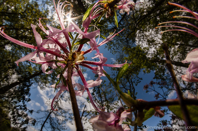
Azalea, Maple Flats Pond. Photo by Steven Johnson
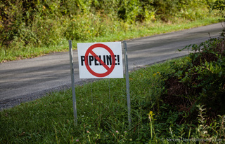 Photo by Steven Johnson
 The Federal Energy Regulatory Commission (FERC) wants to know if you think the Atlantic Coast Pipeline belongs in our national forests.
Comments are due June 2nd.
Comment through FERC's online system or by mail:
Electronically on www.ferc.gov under the link to Documents and Filings, using the eComment feature.
OR
By mailing them to the following address:
Kimberly D. Bose, Secretary
Federal Energy Regulatory Commission
888 First Street NE, Room 1A
Washington, DC 20426
Reference the ACP Docket # CP15-554-000
Comment in Person:
You can also attend one of FERC upcoming open houses:
Marlinton Community Wellness Center
Friday, May 20, 2016
10:00 am – 7:00 pm
320 9th Street
Marlinton, WV 24954
Bath County High School
Saturday, May 21, 2016
10:00 am – 7:00 pm
464 Charger Lane
Hot Springs, VA 24445
New ACP Route - Still Bad News! Below are reasons that no right of way should be approved anywhere in the George Washington National Forest:
Special Biological Areas (SBA)
The pipeline survey route goes through five Special Biological Areas in the GWNF. These lands serve as core areas for conservation of the most significant and rarer elements of biological diversity in the GW. They provide habitat for plants and animals that occupy a small portion of the landscape, but contribute significantly to biological diversity
Remote Backcountry
The 16,680-acre Jerkemtight Roadless Area on the south end of Shenandoah Mountain is the third largest Inventoried Roadless Area in the GW. A big chunk of Jerkemtight along Scotchtown Draft and Deerfield Rd. is within the survey area.
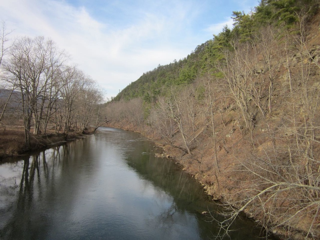
Eligible Recreation River Corridor (See photo below)
The GWNF Corridor for the Cowpasture River is at Ratcliff Hill across from Fort Lewis. This is one of the most beautiful sections of the Cowpasture River, with bald eagles, river otters, a wide variety of waterfowl, and mussels. Scenic quality is outstanding with both mountain and pastoral scenery.
Scenic Corridor and Viewshed
Rt. 250 is a scenic gateway to popular recreation areas, including Braley Pond, North River Campground, Camp Todd, Staunton Dam and Elkhorn Lake, and Hankey Mountain. The forest plan calls for management activities that maintain the natural characteristics that make the area scenic and states that "these areas are unsuitable for designation of new utility corridors, utility rights-of-way, or communication sites".
Recreation Areas (See photo below)
The pipeline route passes close by both Braley Pond Day Use Area and Sherando Recreation Area, two of the most popular in the GWNF.
Trails
The pipeline will negatively affect many trails in the GWNF:
Great Eastern Trail
The pipeline would cross the GET in two places.
Shenandoah Mountain South Trail
Crosses just north of 678, near the Cowpasture and Ratcliff Hill.
Braley Pond Trails
Access could be restricted or cut off and certainly permanently impaired.
Dowells Draft Trail
Pipeline follows Dowells Draft Trail and the Dowells Draft Rd, which is popular for hiking, biking, and hunting.
White Oak Draft Trail
The pipeline would cut across this trail approx. 3000 ft north of Rt. 250
Appalachian Trail
Although the pipeline would tunnel under the AT, the entry and exit points will be visible from popular vantage points, like Humpback Rocks.
Mt. Torry Ridge Trail and Mills Creek Trails
The trailhead for both is at Mt. Torry Furnace, within the pipeline survey boundary
All three of the following are within the pipeline survey boundary:
Back Draft Trail (546)– starts off of SR 641 and goes over Walker Mountain
Short Ridge Trail (717)– starts off west side of SR 629 and goes to FR 399 on Shenandoah Mountain
Brushy Ridge Trail (718) – comes off east side of SR 629, just west of Walker Mountain by Fowler Spring
Visiblility from many more trails
The pipeline corridor will be permanently visible from trails in Ramseys Draft Wilderness, Hankey Mountain, Elliott Knob, Crawford Mountain, Jerkemtight, Signal Corps Knob area, Big Levels, Sherando, Humpback Rocks, Three Ridges Wilderness, and many other locations in the GWNF.
Cultural resources
The route passes through several important cultural resources.
Mt. Torry Furnace
This historic iron furnace near Sherando is on the National Register of Historic Places. It is within the pipeline survey area.
Comments are due June 2nd.
Comment through FERC's online system or by mail:
Electronically on www.ferc.gov under the link to Documents and Filings, using the eComment feature.
OR
By mailing them to the following address:
Kimberly D. Bose, Secretary
Federal Energy Regulatory Commission
888 First Street NE, Room 1A
Washington, DC 20426
Reference the ACP Docket # CP15-554-000
Comment in Person:
You can also attend one of FERC upcoming open houses:
Marlinton Community Wellness Center
Friday, May 20, 2016
10:00 am – 7:00 pm
320 9th Street
Marlinton, WV 24954
Bath County High School
Saturday, May 21, 2016
10:00 am – 7:00 pm
464 Charger Lane
Hot Springs, VA 24445
New ACP Route - Still Bad News! Below are reasons that no right of way should be approved anywhere in the George Washington National Forest:
Special Biological Areas (SBA)
The pipeline survey route goes through five Special Biological Areas in the GWNF. These lands serve as core areas for conservation of the most significant and rarer elements of biological diversity in the GW. They provide habitat for plants and animals that occupy a small portion of the landscape, but contribute significantly to biological diversity
- Browns Pond SBA. (See photo below) 117 acres. Montane Depression wetlands. A sinkhole pond in a dry sinkhole complex in karst topography . Browns Pond has salamanders, frogs, high bush blueberries and other plants characteristic of sinkhole ponds.
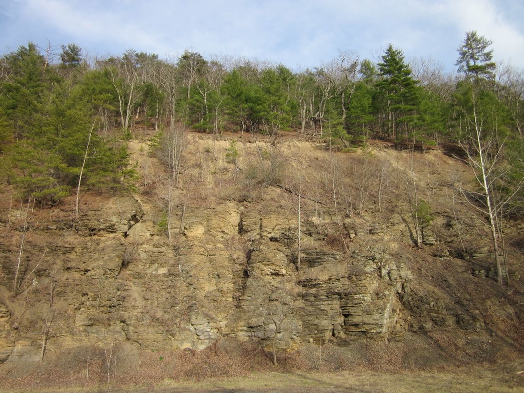
- Ratcliff Hill SBA. (See photo below) 31 acres. Central Appalachian Shale Barren. Located along the Cowpasture River on the east end of the 678 Bridge. Shale barrens are considered globally uncommon and host many locally rare species including the butterflies Appalachian grizzled skipper and Olympia marble and the federally listed plant shale-barren rock cress.
- Big Cedar SBA. 43 acres. Central Appalachian Shale Barren. Near the intersection of Scotchtown Draft and Deerfield Rd.
- Reubens Draft Shale Barren. 39 acres - along Deerfield Rd. south of West Augusta.
- Big Levels Macrosite SBA. (See photo above) 17,793 acres. Montane Depression Wetlands. A tiny corner of the SBA is in the survey area, but it is located close to some of the Maple Flats ponds.
Remote Backcountry
The 16,680-acre Jerkemtight Roadless Area on the south end of Shenandoah Mountain is the third largest Inventoried Roadless Area in the GW. A big chunk of Jerkemtight along Scotchtown Draft and Deerfield Rd. is within the survey area.
Eligible Recreation River Corridor (See photo below)
The GWNF Corridor for the Cowpasture River is at Ratcliff Hill across from Fort Lewis. This is one of the most beautiful sections of the Cowpasture River, with bald eagles, river otters, a wide variety of waterfowl, and mussels. Scenic quality is outstanding with both mountain and pastoral scenery.
Scenic Corridor and Viewshed
Rt. 250 is a scenic gateway to popular recreation areas, including Braley Pond, North River Campground, Camp Todd, Staunton Dam and Elkhorn Lake, and Hankey Mountain. The forest plan calls for management activities that maintain the natural characteristics that make the area scenic and states that "these areas are unsuitable for designation of new utility corridors, utility rights-of-way, or communication sites".
Recreation Areas (See photo below)
The pipeline route passes close by both Braley Pond Day Use Area and Sherando Recreation Area, two of the most popular in the GWNF.
Trails
The pipeline will negatively affect many trails in the GWNF:
Great Eastern Trail
The pipeline would cross the GET in two places.
Shenandoah Mountain South Trail
Crosses just north of 678, near the Cowpasture and Ratcliff Hill.
Braley Pond Trails
Access could be restricted or cut off and certainly permanently impaired.
- Johnson Draft
- Bald Ridge
- Braley Branch Trail
- Braley Pond Trail
Dowells Draft Trail
Pipeline follows Dowells Draft Trail and the Dowells Draft Rd, which is popular for hiking, biking, and hunting.
White Oak Draft Trail
The pipeline would cut across this trail approx. 3000 ft north of Rt. 250
Appalachian Trail
Although the pipeline would tunnel under the AT, the entry and exit points will be visible from popular vantage points, like Humpback Rocks.
Mt. Torry Ridge Trail and Mills Creek Trails
The trailhead for both is at Mt. Torry Furnace, within the pipeline survey boundary
All three of the following are within the pipeline survey boundary:
Back Draft Trail (546)– starts off of SR 641 and goes over Walker Mountain
Short Ridge Trail (717)– starts off west side of SR 629 and goes to FR 399 on Shenandoah Mountain
Brushy Ridge Trail (718) – comes off east side of SR 629, just west of Walker Mountain by Fowler Spring
Visiblility from many more trails
The pipeline corridor will be permanently visible from trails in Ramseys Draft Wilderness, Hankey Mountain, Elliott Knob, Crawford Mountain, Jerkemtight, Signal Corps Knob area, Big Levels, Sherando, Humpback Rocks, Three Ridges Wilderness, and many other locations in the GWNF.
Cultural resources
The route passes through several important cultural resources.
Mt. Torry Furnace
This historic iron furnace near Sherando is on the National Register of Historic Places. It is within the pipeline survey area.


 RSS Feed