
Rough Mountain Wilderness Addition
 Rough Mountain Wilderness © Mark Miller
Approximate size: 1,027 acres
Location: Bath County, James River Ranger District
Topos: Nimrod Hall
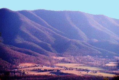
This addition, located on the northern end of the Rough Mountain Wilderness, will expand Rough Mountain from 9300 acres to just over 10,300 acres.
Rough Mountain Wilderness is a steep, highly incised ridge from Griffith Knob to its northern boundary. The addition extends the northern boundary and includes Big Hollow. The inclusion of Big Hollow is significant because it will be the only year round stream within the boundary of Rough Mountain Wilderness. Big Hollow is a narrow, steep-walled canyon with many small tributaries. The entire drainage will be protected, creating a more varied ecosystem.
The Rich Hole/Rough Mountain Wilderness complex is a part of the Lower Cowpasture project, a large landscape-scale planning project involving many diverse stakeholders. These two areas and their respective additions are separated by a narrow tract of private land. When combined, they will create the largest Wilderness complex on national forest land in Virginia (over 21,000 acres).
The Rough Mountain Wilderness addition is located northeast of Clifton Forge, Virginia along SR 42 in Bath County.
Location: Bath County, James River Ranger District
Topos: Nimrod Hall
This addition, located on the northern end of the Rough Mountain Wilderness, will expand Rough Mountain from 9300 acres to just over 10,300 acres.
Rough Mountain Wilderness is a steep, highly incised ridge from Griffith Knob to its northern boundary. The addition extends the northern boundary and includes Big Hollow. The inclusion of Big Hollow is significant because it will be the only year round stream within the boundary of Rough Mountain Wilderness. Big Hollow is a narrow, steep-walled canyon with many small tributaries. The entire drainage will be protected, creating a more varied ecosystem.
The Rich Hole/Rough Mountain Wilderness complex is a part of the Lower Cowpasture project, a large landscape-scale planning project involving many diverse stakeholders. These two areas and their respective additions are separated by a narrow tract of private land. When combined, they will create the largest Wilderness complex on national forest land in Virginia (over 21,000 acres).
The Rough Mountain Wilderness addition is located northeast of Clifton Forge, Virginia along SR 42 in Bath County.
| MapofRichHole&RoughMtnWildernessAdditions.pdf |