
White Oak Ridge/Terrapin Mountain
Approximate size: 8,191 acres
Potential Old-growth: Nearly 2,150 acres of possible old growth can be found throughout the area.
Location: Glenwood Ranger District
Potential Old-growth: Nearly 2,150 acres of possible old growth can be found throughout the area.
Location: Glenwood Ranger District
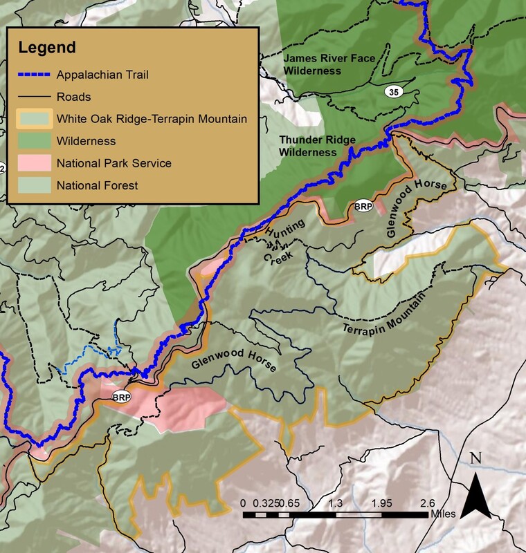
The White Oak Ridge/Terrapin Mountain is located on the eastern slope of the Blue Ridge Mountains in Bedford County. Within the boundaries of the White Oak Ridge/Terrapin Mountain area, there is a dramatic 2,800-foot elevation change between the crest of the Blue Ridge, its outlying knobs, and the base of the mountain. The upper piedmont begins at the base of the mountain and extends to the east.
In this rugged, isolated country, there are several streams which flow to the James River. Four of these streams are designated cold water streams. They are Battery Creek, Hunting Creek, Gunstock Creek, and the numerous tributaries of Overstreet Creek. A small high-elevation wetland forms the beginning of Hunting Creek.
The significant altitude change provides a rich and varied forest. At the base of the mountain, Sweet gum and Yellow poplar are commonly found. In the higher elevations the forest is dominated by Chestnut oak, White oak, Northern red oak, and hickory. There is nearly 2,150 acres of potential old growth, some of which dates to before 1900.
White Oak Ridge/Terrapin Mountain is home to the Apple Orchard Mountain Conservation Site. In addition, there is one Forest Service-recognized Special Biological Area. The area provides important habitat for bear, salamanders, trout, and a number of other deep-forest species.
White Oak Ridge/Terrapin Mountain area has significant recreational opportunities. A short section of the Appalachian Trail passes though White Oak Ridge/Terrapin Mountain near the Blue Ridge Parkway. The Glenwood Horse Trail enters the area at Petites Gap at the north end of the VMT and exits at the western end. In addition to these two nationally recognized trails, the Terrapin Mountain Trail and Hunting Creek Trail provide additional opportunities for recreation.
The Thunder Ridge Wilderness is located across the Blue Ridge Parkway on the western slope of the Blue Ridge.
Access: Access to the White Oak Ridge/Terrapin Mountain area is gained form several locations.
Petites Gap on the Blue Ridge Parkway. This is the north end of the orange blazed Glenwood Horse Trail. 79°27'30.757"W 37°33'33.755"N
The south end of the Glenwood Horse Trail crosses the Blue Ridge Parkway near Floyd Mountain 79°32'58.423"W 37°29'34.254"N
The Appalachian Trail (AT) is located near milepost 76 on the Parkway. 79°30'19.065"W 37°31'28.812"N
The AT again crosses the Parkway near the Thunder Ridge Overlook. The Hunting Creek Trail can be reached from this crossing.
79°29'45.048"W 37°32'13.213"N
The trailhead for the Terrapin Mountain Trail is located on State Route 814 in Bedford County.
79°25'41.446"W 37°31'50.733"N