Thunder Ridge Wilderness Addition
Approximate size:
Thunder Ridge Wilderness: 2,428 acres
Thunder Ridge Wilderness Addition: 1,026 acres Potential Old-growth: 376 acres
Total with Addition: 3,454 acres
Location: Glenwood Ranger District
Thunder Ridge Wilderness: 2,428 acres
Thunder Ridge Wilderness Addition: 1,026 acres Potential Old-growth: 376 acres
Total with Addition: 3,454 acres
Location: Glenwood Ranger District
Thunder Ridge Wilderness Addition

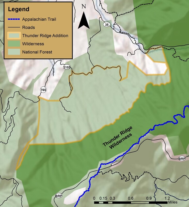
The 1,026 acres addition to the Thunder Ridge Wilderness is located on the northern edge of the Thunder Ridge Wilderness in Rockbridge County. The addition includes the lower slope of Thunder Ridge pushing the western boundary of the Thunder Ridge Wilderness to its logical maximum extension.
The addition is composed mostly of rich hardwood forests including Chestnut oak and mixed stands of White oak, Northern red oak, and different types of hickory. Near the Wilderness boundary on the upper slopes of the addition, some of these trees are very large, including one grove that date back to the 1800s.
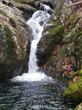
Hopper Ridge forms the western boundary and just below the ridge is the headwater of Hopper Creek. When the water is high, it sports a significant waterfall. Near FR 3105 there is another unnamed stream. Just to the east of this stream is a small alluvium wetland. This area is filled with moss covered rocks and a stand of small Yellow birch and Black cherry.
There are 376 acres of potential old growth, mostly White Oak, Northern red oak, and hickory. A small section of the Apple Orchard Conservation site is located in the addition.
There are no officially designated trails in the Thunder Ridge Wilderness addition.
Access: This addition can be accessed from the Hopper Creek Group Campground and FR 3105. This is the Thunder Ridge Road but access is restricted to hunting season. Note: There are no designated trails.
79°30'33.314"W 37°33'46.554"N
Thunder Ridge Wilderness

Thunder Ridge Wilderness is in Rockbridge, Botetourt, and Bedford Counties. Established in 1984, this 2428-acre treasure is the smallest wilderness in Virginia. However, its small size is not indicative of its true nature. Thunder Ridge Wilderness is a rugged region and not for the faint of heart. Located below the crest of its namesake Thunder Ridge, this wilderness rises almost 3000 feet from Arnolds Valley to the summit of Apple Orchard Mountain on the crest of the Blue Ridge.
Thunder Ridge Wilderness is separated from the larger James River Face Wilderness by Petites Gap Road. Together, with their additions, they would create 14,400 acres of nearly contiguous wilderness land.
At the very southern end of the Thunder Ridge Wilderness several small unnamed creeks come together to form the upper reaches of North Creek a tributary of the James River. The same is true for Hopper Creek. Numerous smaller streams come together near the wilderness boundary to form Hopper Creek. One creek has a significant waterfall. North Creek and Hopper Creek are separate by Hopper Ridge. This ridge exceeds 3000 feet.
Going north Thunder Ridge Wilderness is deeply incised by numerous small streams all of them unnamed. These streams are either tributaries of Hopper Creek or Elk Creek. A walk up any one of them is a difficult and challenging task. At the northern end of Thunder Ridge Wilderness there is one designated cold-water stream. This unnamed stream begins just below the crest of the Thunder Ridge and cascades down the mountain to Elk Creek.
The crest of the Blue Ridge hosts many high elevation tree species including Yellow birch, Black cherry and Northern red oak. Young Red spruce dots the landscape near the crest of Apple Orchard Mountain. Trillium, Columbine, Pink lady slipper and Mayapple thrive on the moist forest floor.
There are two trails that pass-through Thunder Ridge Wilderness. Going south the Appalachian Trail enters just below the meadow on the summit of Apple Orchard Mountain. Here it drops off the ridge and pass under Guillotine Rock before exiting the wilderness. It reenters the Wilderness and be-gins to descent to Petites Gap. The Glenwood Horse Trail climbs up the ridge on the northern end of the wilderness.
Access: The Thunder Ridge Wilderness can be accessed from several places. These include the Glenwood Horse Trail on FDR 35. The AT crosses FDR 35 and enters Thunder Ridge Wilderness at Petites Gap on FDR35 near the Blue Ridge Parkway. Access via the AT is also available on the Blue Ridge Parkway near Milepost 76 and at the Sunset Fields parking areanear Milepost 78.

